 |
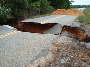
Beginning 28 April 2009, the State of Arkansas experienced severe storms and flooding, affecting 37 counties and causing damage to infrastructures. This resulted in the 16 June 2009, presidential disaster declaration, DR-184, for Public Assistance. In Lafayette County alone, four roads were washed out, necessitating repairs and mitigation.
When technical advice from a Public Assistance Specialist recommended using a geotextile to stabilize the embankment and make the road more resilient once repairs were completed, Lafayette County’s Emergency Management Coordinator James Barnes became concerned about how well it would work. A geotextile fabric is a material that is utilized in foundations, earth, rocks, and soil. It is also referred to as erosion control cloth, filter fabric, support membrane, and civil engineering cloth. As a mitigation measure, the geotextile increases resistance to localized flooding damage by reinforcing roadway sub-base and by improving sub-base drainage. Geotextiles are designed to be permeable to allow the flow of water through it. The terms “fabric” and “cloth” raised skepticism.
Very heavy rainfall from a series of storms produced large volumes of surface runoff, which overtopped CR 22 and resulted in a washout of a large section of the road and two culverts. CR 22 is primarily used as a short-cut road between the cities of Stamps and Lewisville.
“Water was probably six to eight inches over the road during the flood event of May 2009. This was the first time CR 22 had ever washed out,” said Barnes. “After the flood event, we replaced the two culverts. Before we could do any kind of mitigation, more rain came and one of the culverts washed out again. When we were advised to try the geotextile fabric, we were really skeptical. We just didn’t think that stuff would work. We had never done this before.”
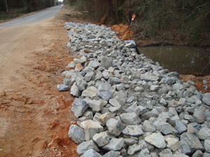
The county received funding through the Federal Emergency Management Agency’s (FEMA) Public Assistance (PA) 406 Mitigation. Total project cost of repairs and mitigation was $19,110.22. The hazard mitigation proposal included compacting soil and installing the geotextile drainage blanket. A layer of riprap was placed over the geotextile. At an estimated cost of $5,220.00 the mitigation project was initiated on 21 May 2009, and took four and one-half hours to complete.
 |
“It wasn’t that hard to do. In fact, it’s fast and easy,” said Barnes.
“Some counties turn the idea down because they assume that it’s time consuming,” added Teresa Smith, Arkansas’ southeast area coordinator.
When placed between the soil and a culvert, gabion, or retaining wall, geotextiles enhance water movement and retard soil movement, and serves as a blanket to add reinforcement and separation. Geotextiles are useful for moderate-flow storm water channels, banks, and steep slopes where both immediate and long-term erosion control is needed. Woven and nonwoven geotextiles are specifically designed to protect roadways from subsurface saturation, strengthen and consolidate soil, reduce maintenance costs, and make a project easier to manage.
“The benefits in a long run will pay for the project. It’s a viable means of protecting the culvert and the roadway. It’s cost effective and it’s not time consuming,” said Barnes. “We are using geotextiles on all of the road projects that we are presently working on and those that we will be working on. We are sold on it. It works. After a while, it looks like part of the landscape.”
Project details are posted below.
|
SUBMIT A BEST PRACTICE STORY TO FEMA FEMA welcomes submissions for its Mitigation Best Practices Portfolio. For information on how to submit your project story, visit the Best Practices home page: http://www.fema.gov/plan/prevent/bestpractices/index.shtm FEMA does not endorse any product or company. This article has been reprinted by permission. |
PROJECT DETAILS
Activity/Project Location
- Geographical Area: Single County in a State
- FEMA Region: Region VI
- State: Arkansas
- County: Lafayette County
- City/Community: Lewisville; Stamps
Key Activity/Project Information
- Sector: Public
- Hazard Type: Flooding
- Activity/Project Type: Flood Control
- Activity/Project Start Date: 05/2009
- Activity/Project End Date: 05/2009
- Funding Source: Other FEMA funds/ US Department of Homeland Security
- Funding Recipient: Local Government
Activity/Project Economic Analysis
- Cost: $6,525.00 (Actual)
- Non FEMA Cost: $1,305.00
Activity/Project Disaster Information
- Mitigation Resulted From Federal Disaster? Yes
- Federal Disaster #: 1834, 04/27/2009
- Year of disaster that resulted in mitigation effort: 2009
- Value Tested By Disaster? Yes
- Tested By Federal Disaster #: 1861, 12/03/2009
- Repetitive Loss Property? No


