Two years ago, the International Erosion Control Association (IECA) held its annual conference and exhibition in Long Beach, California. The gathering occurred just after what had been a brutal year of wildfires in California. In fact, just a month before the event, the Santa Barbara area had been particularly hard hit. The opening keynote turned out to be exceedingly timely: post-wildfire remediation on federal lands. Penny Luehring, USDA Forest Service Burned Area Emergency Response Program Leader, delivered an exceptional address and peeled back a number of common assumptions about what we should focus on with wildfire response strategies.
One of the items Luehring emphasized was that wildfire response was not simply a matter of revegetation and restoring an ecosystem. Flooding and debris flow following wildfires was a major environmental challenge and a threat to public safety. Post-wildfire flash floods had caused deaths miles away from a fire threat. It was an issue that could not be ignored in one’s considerations of wildfire response strategies.
Responding to wildfires was as much about preventing future threats as it was about remediating the current environment. Luehring asked everyone to see wildfire response in the larger context of infrastructure and flood mitigation.
WILDFIRE RESPONSE, DEBRIS FLOW ANALYSIS & INFRASTRUCTURE
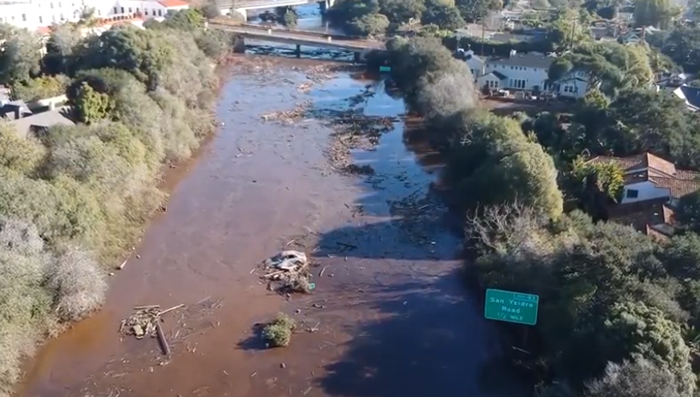
Following the January 2018 wildfires and post-wildfire floods in the Santa Barbara, the debate on improving models on debris flow intensified. The US Army Engineer Research and Development Center (ERDC) Coastal and Hydraulics Laboratory took up the challenge.
“As the wildfire ends, our work begins,” ERDC writes on its YouTube video post about the debris flow research.
MORE GEO: Flood Protection Strategies with Geosynthetics
But, the agency does not see this simply as a reactive strategy. It is just as relevant for re-imagining our infrastructures so that the potential for and impact of debris flow is minimized.
“What we’re going to try to do is provide the modeling metrics so that they can improve infrastructure to absorb those post-wildfire floods,” says ERDC’s Ian Floyd, a Research Physical Scientist. He does a great job in the video of describing how debris flow emerges after a flood and why ERDC’s modeling is unique.
He’s also supported by comments from the local level, where the modeling will be most useful.
“You don’t have a whole lot of time between a fire and a potential rain event that could cause a debris flow,” says John Frye, Water Resource Engineering Manager for Santa Barbara County Public Works. “We need mapping and tools in hand that can help us plan protective measures.”
In the video, Frye stresses that ERDC’s work offers tremendous potential to beneficially change fire remediation and flood prevention strategies. It may also change how we prioritize funding in these areas, with an eye to improving infrastructure in line with the debris flow modeling being advanced by ERDC.
“Most of the modeling that is done along the creeks is a water model,” Frye says. “A debris flow model, which is what ERDC is doing, is a different science.”
To learn more about ERDC’s work, visit https://www.erdc.usace.army.mil/.


